-
Astronomy & Astrophysics
From the birth of stars to the mysteries of black holes and the structure of the cosmos, Astronomy & Astrophysics research at IIST explores a wide spectrum of cosmic phenomena. Our team of six faculty members brings together extensive multiwavelength observational expertise and theoretical insight.
Key research themes
- Formation of massive stars in our Galaxy
- Investigation of the interstellar medium
- Accretion around compact objects
- Gamma-ray bursts and gravitational wave astronomy
- Intergalactic medium and galaxy halos
- Machine learning techniques to study astrophysical sources
Broader vision and collaboration
We are actively engaged in national and international collaborations and big projects.
- IIST faculty members are actively engaged in the Indian multiwavelength ASTROSAT mission.
- India is a member country of the upcoming Square Kilometre Array (SKA) observatory, the world’s largest radio telescope. IIST is a part of the SKA-India consortium, which oversees the educational and research activities related to SKA science in India.
- IIST is a member institute in the Belgo-Indian Network for Astronomy and Astrophysics (BINA)
Astronomy lab
At the IIST campus, there is an astronomical observatory with a 14-inch and an 8-inch telescope with imaging and spectroscopic capabilities. The facility is used for undergraduate and postgraduate labs where students get hands-on experience in carrying out interesting night sky observations. In addition, an 8-inch telescope is dedicated exclusively to outreach activities. The observatory facility is in the process of being upgraded with a new telescope.
Apart from this, there is an Astronomy Lab for instrument characterisation. This lab is also equipped with desktops and workstations for data reduction and analysis.
Studying astrophysics at IIST
Currently, IIST takes students through advanced JEE for a five-year dual degree (BTech in Engineering Physics and Master of Science in Astronomy & Astrophysics) program, of which the fourth and fifth years are dedicated to doing astronomy. In addition, a two-year Master of Science in Astronomy & Astrophysics for engineering graduates and MSc holders is offered every year. The students undertake one year of coursework followed by a year dedicated to a master’s thesis.Doing astrophysics at IIST
Students can enroll for the doctoral program in astrophysics in the Department of Earth and Space Sciences twice a year (in January and August).
IIST has an official summer internship program during June and July. The announcement of internship opportunities is made available on the IIST website typically in the month of April.
Anyone interested in a postdoctoral or research internship position is encouraged to contact individual faculty members.
-
Atmospheric Sciences
The Atmospheric Science group comprises three faculty members engaged in both numerical modeling and observational studies of the atmosphere. Their primary focus lies in enhancing mesoscale model performance through the assimilation of non-conventional data sources, including satellite observations, using advanced data assimilation techniques.
Group members also have expertise in deploying and analyzing data from atmospheric boundary layer towers to address key scientific questions. One faculty member specializes in aerosol measurements and investigates their impact on cloud microphysics and the radiation budget, particularly in the context of climate change.
The group’s research spans several thrust areas: monsoon climate studies, climate and mesoscale modeling, data assimilation, aerosols and their role in climate change, radiation–climate interactions, atmospheric boundary layer processes, the use of unmanned aerial vehicles (UAVs) as research platforms, and the development of miniaturized instrumentation for space applications. Recently, the group has also incorporated machine learning (ML) techniques to advance research across these domains.Key Research Areas:
- Atmospheric Modelling
- Data assimilation & Weather Predictability
- Aerosols and climate interactions
- Radiation–climate interactions
Studying Atmospheric Science in IIST
IIST currently admits students through the Advanced JEE examination into a five-year dual degree program, which awards a BTech in Engineering Physics and an MTech in Earth System Science. During the fourth and fifth years of this program, students focus on specialized courses in Atmospheric Science and Geology. Additionally, the institute offers a separate two-year MTech program in Earth System Science, open to graduates with an engineering degree or an MSc. This program includes one year of academic coursework followed by a year devoted to independent research culminating in an MTech thesis.
Research Facilities:
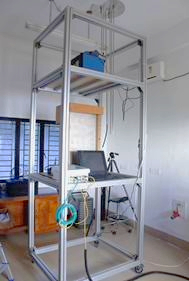
The Ponmudi Climate Observatory (PCO), operated by the IIST, is a premier research facility located atop the Western Ghats in Kerala at an elevation of 1,000 meters above mean sea level (8.76°N, 77.12°E). This high-altitude site offers a unique environment for atmospheric studies, particularly during the summer monsoon season when it is often enveloped by clouds, providing an ideal natural laboratory for investigating aerosol-cloud interactions and other atmospheric processes. Key Research Facilities at PCO include Aerosol Instrumentation, LIDAR Ceilometer, Cloud Condensation Nuclei Counter, Micro Rain Radar, Disdrometer etc. In addition to this, access to high-performance computing clusters are available for Atmospheric Modelling studies.
IIST Ponmudi Climate Observatory (IIST-PCO) Research Facilities @ IIST Ponmudi Climate Observatory
IIST has established a Climate Observatory at its Ponmudi Campus on the hilltop of the Western Ghats (PCO, 8.76°N, 77.12°E, 1 km, AMSL). It is equipped with state-of-the-art field instrumentation for measuring aerosol and cloud microphysics along with meteorological variables. Over the years, many observational campaigns covering greenhouse gases (GHG), meteorology, boundary layer, aerosol-cloud interactions, and radiation balance studies have been carried out by the faculty of IIST. These instruments are also extensively used for lab and teaching courses at IIST.
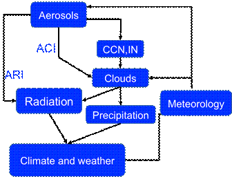
Aerosol-Cloud Interaction IIST Balloon Launch Facility
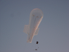
Atmospheric research is one of the strongholds of IIST, with a fully owned and dedicated research facility at PCO. The observatory is one of its kind in the country, with provisions for balloon-borne measurements from near-surface to stratosphere (35 km) in the frontiers of Atmospheric Sciences, Astronomy, Astrobiology, high energy Physics, and space technology development. Students/faculty at IIST may be encouraged to build and quickly test payloads and conduct high quality research in the lower Earth's atmosphere.
A new collaborative program on the measurement of vertical profile of ozone along with meteorological parameters at multiple sites (Ponmudi, Hyderabad, Nagpur, Jodhpur) has been initiated under the coordination and support of the Earth & Climate Area (ECSA) of the National Remote Sensing Centre (NRSC/ISRO). As part of this study, coordinated monthly launches are undertaken at four sites.
Balloon launch from Ponmudi Climate Observatory
Tethered balloons for testing small payloads up to 1 km altitude
Tethered balloons of volume 9.0 m3 capable of carrying 1.0-3.0 kg payload weight up to an altitude of about 1 km are also available for conducting various scientific experiments
Photograph showing the hoisting of a Tethered balloon (Kytoon). Optical particle counter (OPC) is seen tied to the belly strings. Small payload development for space research
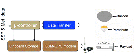
A frequent access to space for university groups like IIST to make small autonomous payloads that will perform high-quality scientific investigations has become available with the maturing of the ISRO launch capabilities. This, in turn, requires training of graduate students, young scientists and engineers in “hands-on” research techniques used in space experiments. Student satellite (Studentsat) program (SSP), which is a balloon-based interdisciplinary program, provides an educational experience to students, young scientists, and engineers in the design and data analysis of a space experiment (up to 35 km). Studentsat can have a compendium of lightweight payloads (sensors) for remote sensing, atmospheric sciences, biology, chemistry, and astronomy designed by students within the mass and power constraints. It offers opportunities to have hands-on experience on complex processes of design, development, testing, and integration of state-of-the-art sensors to probe the space environment and data analysis. It provides an affordable way to acquire the basic knowledge and many challenges in building a payload for space research and technological development. It offers an opportunity to the space scientist to gain the first experience of the real space mission program, starting with design, testing, integration, launching, data analysis, and presentation of results. It offers the students (undergraduate and postgraduate students and Ph.D.) to design and build a small scientific satellite payload to gain first-hand experience of the actual space mission program /planetary exploration and nurture future space scientists and engineers in the country.
Student satellite (Studentsat) program -
Remote Sensing
In a data-driven era, geospatial information has become an essential asset, applicable in areas such as urban planning and the monitoring of environmental and natural resources. This data offers vital insights into the spatial aspect of information, facilitating informed decision-making across various sectors. The growing complexity of global issues—like urbanization, climate change, disaster management, and natural resource oversight—has heightened the necessity for precise and timely geospatial data.
The Remote Sensing Group within the Department of Earth and Space Sciences consists of three faculty members dedicated to analyzing geospatial data and advancing geoinformatics. Their research emphasizes the development of innovative methods and techniques for processing and interpreting data obtained from a diverse array of geospatial sensors, including Unmanned Aerial Vehicles (UAVs), ground-based systems, and satellite platforms.
The group extensively utilizes data from multispectral, hyperspectral imaging, microwave, LiDAR, and other remote sensing technologies to tackle real-world challenges. Their research encompasses various application domains, such as agriculture, urban studies, coastal zone monitoring, and disaster management. By integrating sophisticated geospatial analytics, machine learning techniques, and multi-sensor data fusion, the Remote Sensing Group makes significant contributions to both scientific research and practical solutions aimed at sustainable development and environmental management.
Beyond research, the group is instrumental in providing the M.Tech program in Geoinformatics, which has been successfully operating since 2013. With an annual enrollment of 10 students, the program draws candidates from open channels as well as from organizations like ISRO and DRDO. Graduates of this program often secure positions in leading geospatial organizations.
The group is also actively involved in several externally funded research projects, supported by national agencies and organizations. These projects focus on cutting-edge technologies and address pressing real-world problems, including climate resilience, smart agriculture, urban sustainability, coastal ecosystem monitoring and disaster preparedness.
Through a blend of cutting-edge research and academic excellence, the Remote Sensing Group continues to contribute to the advancement of geospatial technologies for sustainable development and scientific discovery.
Key Research Areas:
Studying Geoinformatics at IIST
- The M.Tech in Geoinformatics program at the Indian Institute of Space Science and Technology (IIST) is designed to provide in-depth knowledge and practical skills in the field of geospatial science and technology.
- The program admits 10 students annually, including open category and sponsored candidates.
- The admission is through valid GATE score as given in the IIST admission portal
Graduates of the program have an excellent track record, finding placements in leading geospatial companies, government agencies, and research institutions, or pursuing doctoral studies in India and abroad. The program prepares students to be at the forefront of geospatial innovation, contributing to national development and global scientific advancement.
Remote Sensing lab
The Remote Sensing Lab at the Indian Institute of Space Science and Technology (IIST), housed within the Department of Earth and Space Sciences, is a dedicated facility for research and education in the field of geospatial science and technology. The lab supports a wide spectrum of activities in remote sensing, geoinformatics, and spatial data analysis, facilitating both academic learning and advanced research.
Equipped with high-performance computing systems, image processing software, and specialized tools for handling data from hyperspectral, LiDAR, UAV, and satellite-based sensors, the lab enables the development of innovative techniques for geospatial data processing and interpretation.
The Remote Sensing Lab serves as a key resource for the department’s M.Tech in Geoinformatics program, providing students and researchers with hands-on experience in analyzing and applying remote sensing data to real-world problems. Research conducted in the lab spans diverse application areas including agriculture, forestry, urban planning, coastal studies, and disaster management.
Lab Facilities
INSTRUMENTS
- GARMIN HANDHELD RECEIVER GPS
- MIRROR STEREOSCOPE WITH BINOCULAR 3X IN WOODEN BOX
- DISTO D8 HANDHELD LASER DISTANCE METER, WITH RANGE:0.05M TO 200M FT/INCH.
- FIELDSPEC HANDHELD (325- 1075 NM)/ITEM NO. A103000
- FIELDSPEC 4-ASD 350-2500 NM
- PART NO. 75000-20 TRIMBLE R3 DGPS SYSTEM
- PORTABLE CHLOROPHYLL CONTENT METER, MODEL MC-100
- FARO TERRESTRIAL LASER SCANNER
- LEICA DISTO S910 LASER DISTANCE METER
- USB QUANTUM SENSOR MODEL SQ420
- PLANT CANOPY ANALYZER, MODEL CI-110
- SVC HYPERSPECTRAL SPECTRORADIOMETER
- HYPERSPECTRAL IMAGER
- GNSS RECEIVER
- UAV WITH MULTISPECTRAL AND RGB CAMERA
LIST OF LICENSED SOFTWARES
- ENVI 5.6
- ERDAS 2018
- TERRASOLID
- eCognition Developer 9.6
- ArcGiS10.8.2
- Pix4D
-
Solid Earth
The department has one geologist who is actively pursuing multitudes of research projects on planetary geosciences. Solid Earth group concerns itself with the study of processes associated with the origin and evolution of various rocks and minerals on Earth and nearby solar system bodies, particularly the Moon and Mars. The specific research themes include the study of evolution of Earth’s mantle and lower crust, behaviour of trace and rare-earth elements in igneous and metamorphic systems, chromite genesis in ultramafic-mafic rocks, mineral deposits associated with various rok types and significance of fluid inclusions in economic mineral deposits, stable and radioactive isotopes in igneous petrogenesis and genesis of anorthosites in earth and moon.
The Geology group is planning to develop an active research base in Planetary Geoscience studies at the institute. The faculty has started collaboration with SAC, Ahmadabad and PRL, Ahmadabad on future Planetary Science exploration programmes such as PLANEX and Chandrayaan-2. The group has started working on identifying and studying terrestrial sites that are lunar and Martian analogues. Geological fieldwork will be carried out at these sites in addition to mock in-situ experiments for the proposed space planetary missions.


Event Details
Select a date to view events.